Robber’s Roost II
via Fremont Saddle
Last year I hiked to Robber’s Roost via the Carney Springs Trail. This year (February 16, 2024) Kim and I hiked to Robber’s Roost via the Peralta Canyon Trail and Fremont Saddle. It was fun to share “the Roost” and the views out the fractures with Kim.
Walk-Specific Map
See Superstition Wilderness Overview page for an overview map of all hikes.
Take Note
- Click on a segment to get specific information.
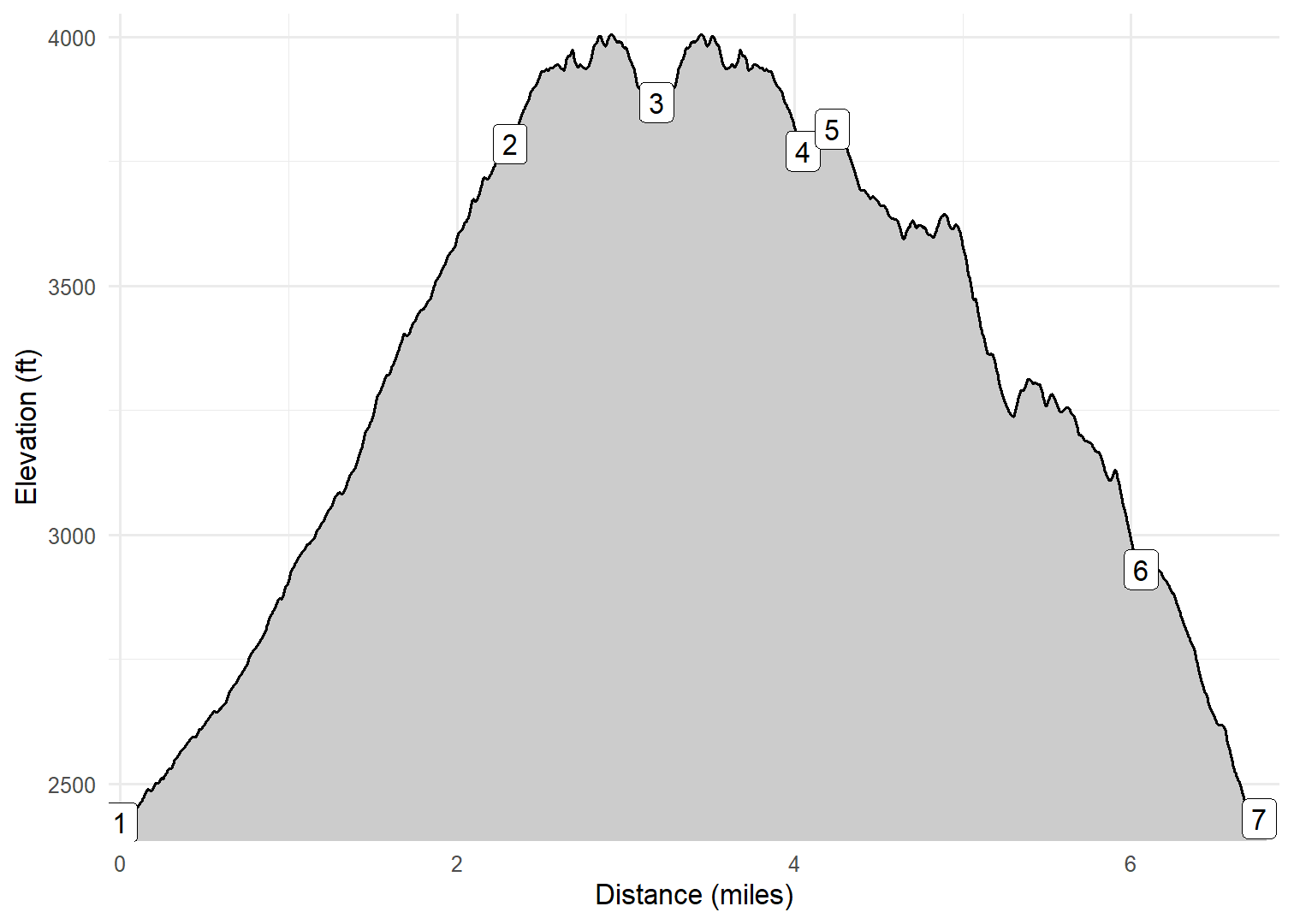
- Numeric labels correspond to the same labels in the elevation profile and summary information below.
- See Superstition Wilderness Overview page for description of use of controls.
Elevation Profile
Images

BLUFSP01: Looking south from Bluff Spring Trail

BLUFSP01: Typical scenery in winter 2024

GERCAV01: Kim scrambling

GERCAV01: Kim scrambling

GERCAV01: Kim scrambling

GERCAV01: Thankful for cairns

GERCAV01: Looking south down Peralta Canyon

GERCAV01: Looking north up Peralta Canyon

GERCAV01: Me on the Cave Trail

GERCAV01: Kim on the Cave Rrail

GERCAV01: Looking back on the Cave Trail

GERCAV02: Typical scenery in Spring 2022

GERCAV02: Typical scenery in Spring 2022

GERCAV02: Typical scenery in Spring 2022

GERCAV02: Geronimo Cave

GERCAV03: Kim and I on Fremont Saddle

GERCAV03: Weavers Needle from Fremont Saddle

GERCAV03: Weavers Needle on way to Pinon tree

PRLTCN01: Taking off!

PRLTCN01: Looking south down Peralta Canyon

PRLTCN01: Looking north up Peralta Canyon

PRLTCN01: Sign near trailhead

PRLTCN01: Typical scenery in Spring 2022

PRLTCN01: Typical scenery in Spring 2022

PRLTCN01: Typical scenery in Spring 2022

PRLTCN01: Typical scenery in Spring 2022

PRLTCN01: Typical scenery in Spring 2022

PRLTCN01: View down Peralto Canyon

PRLTCN01: Kim and I in Peralta Canyon

PRLTCN01: Lots of water around

RDGLIN01: Weaver’s Needle

RDGLIN01: Looking down on the Peralta Tr

RDGLIN01: Looking east across Peralta Canyon

RDGLIN01: Kim with Weavers Needle

RDGLIN01: Hoodoo formations before Roost

RDGLIN01: Me in the Roost

RDGLIN01: Kim in the Roost

RDGLIN01: Me in the Roost

RDGLIN01: Kim coming out of the Roost

RDGLIN01: View out of the Roost

RDGLIN01: Kim in the Hoodoo formations
GPX Download
A sanitized GPX file of our hike is here.
Summary Information
| NUM | trackID | Primary | Description | Distance | CumDist | DeltaElev |
|---|---|---|---|---|---|---|
| 1 | PRLTCN01 | Peralta Canyon Tr (102) | Peralta TH to Fremont Saddle | 2.27 | 2.27 | 1361 |
| 2 | RDGLIN01 | Superstition Ridgeline Tr | Fremont Saddle to Robber's Roost Tr | 0.75 | 3.02 | 124 |
| 3 | RBRRST01 | Robber's Roost Tr | Superstition Ridgeline Tr to Robber's Roost | 0.09 | 3.11 | -40 |
| 4 | RBRRST01 | Robber's Roost Tr | Robber's Roost to Superstition Ridgeline Tr | 0.09 | 3.21 | 40 |
| 5 | RDGLIN01 | Superstition Ridgeline Tr | Robber's Roost Tr to Fremont Saddle | 0.75 | 3.96 | -124 |
| 6 | GERCAV03 | Geronimo Cave Tr (233) | Fremont Saddle to Pinyon Tree Tr | 0.15 | 4.11 | 40 |
| 7 | GERCAV02 | Geronimo Cave Tr (233) | Pinyon Tree Tr to Geronimo Cave | 0.67 | 4.79 | -112 |
| 8 | GERCAV01 | Geronimo Cave Tr (233) | Geronimo Cave to Bluff Spring Tr | 1.07 | 5.85 | -717 |
| 9 | BLUFSP01 | Bluff Spring Tr (235) | Geronimo Cave Tr to Dutchman's Tr | 0.68 | 6.53 | -504 |
| 10 | DTCHMN01 | Dutchman's Tr (104) | Bluff Spring Tr to Peralta TH | 0.05 | 6.59 | -13 |