Wanatee County Park
Southern Perimeter Trail I
While home to visit family, Cash and I walked a loop of trails at the Wanatee County Park. The loop started on the west side and roughly went along the southern perimeter before jumping on a bike trail and the road for a bit to hit the hiking trail along the ponds just north of Red Cedar Lodge. It was a nice walk through a variety of habitats. It was a bit disheartening to see the damage from the 2020 derecho, but that is nature. It will be fun to be back to hit some of the other trails.
Walk-Specific Map
NoteTake Note
- Click on a segment to get specific information.
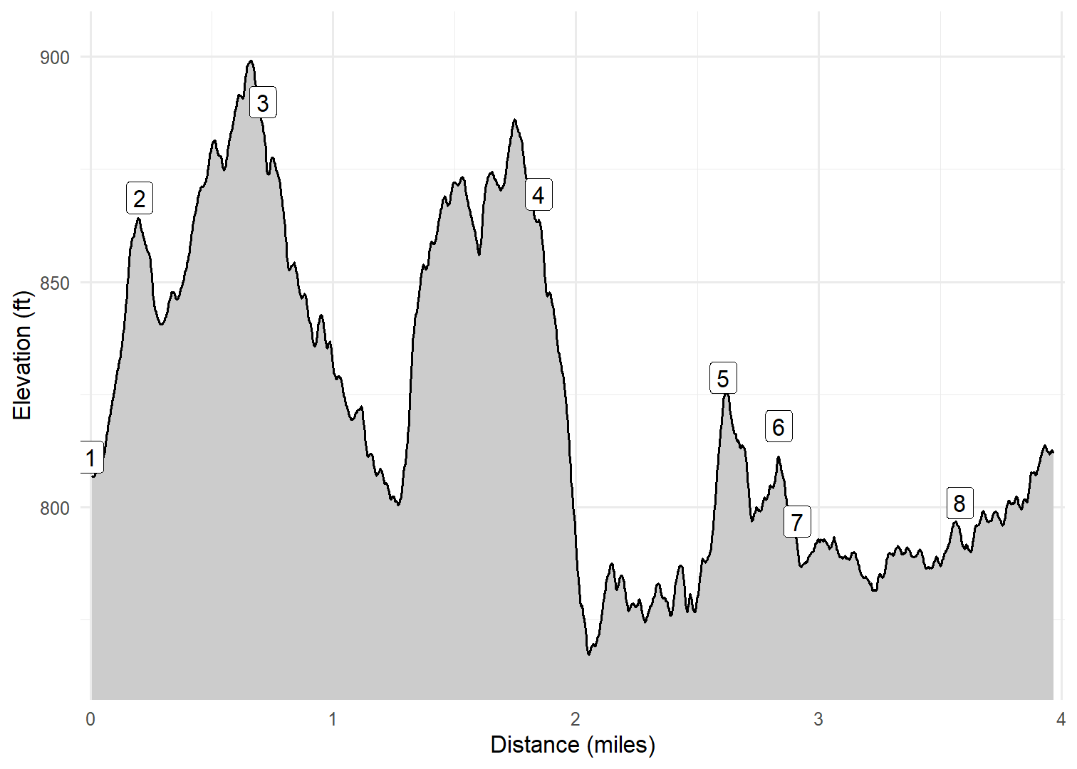
- Numeric labels correspond to the same labels in the elevation profile and summary information below.
Elevation Profile
GPX Download
A sanitized GPX file of our hike is here.
Summary Information
| NUM | trackID | Primary | Description | Type | Distance | CumDist | DeltaElev |
|---|---|---|---|---|---|---|---|
| 1 | IAWNTE01 | Wanatee Park | S 31st St parking area to Equine trailhead | Trail | 0.20 | 0.20 | 58 |
| 2 | IAWNTE05 | Wanatee Park | Equine trailhead to Meadowlark Shelter area | Trail | 0.51 | 0.71 | 21 |
| 3 | IAWNTE10 | Wanatee Park | Meadowlark Shelter area to Lakeside Rd parking area | Trail | 1.14 | 1.85 | -20 |
| 4 | IAWNTE15 | Wanatee Park | Lakeside Rd parking area to XXX bike trail | Trail | 0.76 | 2.61 | -41 |
| 5 | IAWNTE20 | Wanatee Park | XXX hiking trail to Big Bluestem Cir Rd | Trail | 0.23 | 2.84 | -11 |
| 6 | IAWNTE30 | Wanatee Park | XXX bike trail to XXX hiking trail | Trail | 0.08 | 2.91 | -21 |
| 7 | IAWNTE40 | Wanatee Park | Big Bluestem Cir Rd to Red Cedar Lodge area | Trail | 0.67 | 3.58 | 4 |
| 8 | IAWNTE45 | Wanatee Park | Red Cedar Lodge area to S 31st St parking area | Trail | 0.39 | 3.98 | 17 |